Sea Ice Chokes the Northwest Passage
Since the first vessel transited the fabled Northwest Passage in 1906, fewer than 400 voyages through it have been recorded. Treacherous and unpredictable Arctic waters challenge seafarers navigating the cluster of islands north of mainland Canada. The passage remains enticing, however, for the distance it can save on the journey between the Pacific and Atlantic oceans.
Declining sea ice thickness and extent in the Arctic amid a warming climate is generally believed to make this passage more viable for longer windows each summer. But in recent years, according to a new analysis in Communications Earth & Environment, the southward drift of ice has been clogging it up, causing a significant reduction in the length of the shipping season between 2007 and 2021.
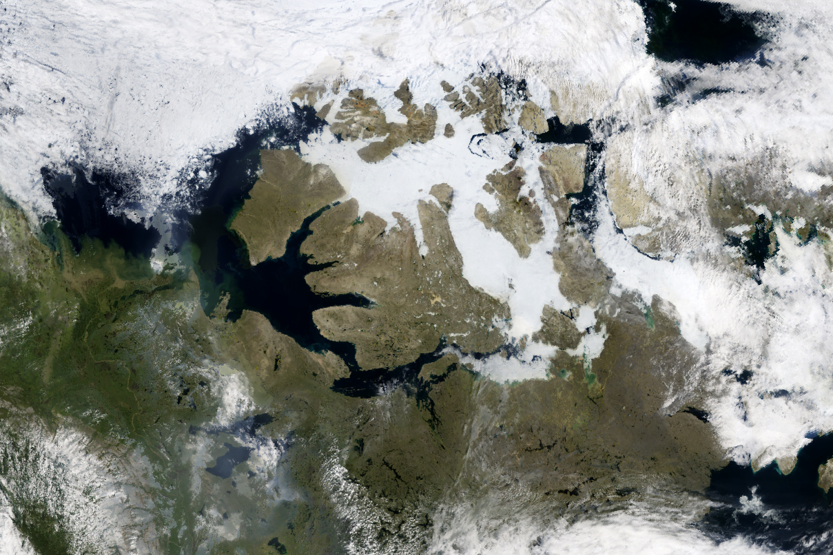
On July 13, 2024, the OCI (Ocean Color Instrument) aboard NASA’s PACE (Plankton, Aerosol, Cloud, ocean Ecosystem) satellite captured a rare, mostly cloud-free image of the islands and waterways that form the crux of the Northwest Passage. Ships making this transit along northern Canada must skirt Victoria Island either to the north or the south. Each route comes with its own “choke points” where ice tends to accumulate and linger. In this image, ice appears to obstruct all paths.
This is despite the fact that, on July 15, during the peak of the melting season, Arctic sea ice extent ranked seventh lowest in the satellite record for that date, according to the National Snow and Ice Data Center (NSIDC). Around the Canadian archipelago, most of which is shown here, sea ice “looks to be near record-low levels for this time of year,” said Walt Meier, a sea ice scientist at NSIDC. Ice along the southern route should clear out well in advance of the typical sea ice minimum in late September, he added, but coverage in the channels is subject to change depending on how winds transport drifting ice.
Forty years of satellite data show that Arctic sea ice cover has been declining for decades. In addition to the ice cover shrinking, melting seasons are getting longer and sea ice is losing its longevity. Sea ice older than four years covered nearly 2.5 million square kilometers at the end of the summer melt season in September 1985, according to NOAA’s 2023 Arctic Report Card. In September 2023, old ice covered less than 100,000 square kilometers.
Some researchers think old sea ice on its way out is impeding shipping in the Northwest Passage. “Results show that multiyear ice flushed southward from high-latitude regions maintains the so-called choke points along certain route sections, reducing overall shipping season length,” wrote the study authors. Older, thicker ice is more resilient to changes in the atmosphere and ocean. It also loses some of its salt content, allowing it to stay frozen at higher temperatures.
“In the past, much of the Northwest Passage would remain ice-covered, which would block inflow from the Arctic Ocean,” said Meier, who was not involved with the study. Now, as the channels melt out, he said, thick ice that is hazardous to shipping can flow in. And while there is not a lot of multiyear ice remaining in the Arctic, much of it resides around the northern Canadian islands and Greenland, he said. “It is just in the right spot to potentially infiltrate the channels of the archipelago.”
NASA Earth Observatory image by Michala Garrison, using PACE data from NASA EOSDIS LANCE and GIBS/Worldview. Story by Lindsey Doermann.