Boots on the Ground in Iran… A Deception or a Suicide Mission?
As of March 20, 2026, the United States has ordered two Marine Expeditionary Units (MEUs) to the Arabian Sea/Middle East region amid the ongoing US-Israel war with Iran (Operation Epic Fury, started February 28, 2026). Why is the Trump administration announcing this when it is at war with Iran. Normally, a commander wants to hide their troop movements. This is either criminal negligence on the part of Trump’s Department of War or it is part of a deception operation. Let’s first look at their composition and expected arrival time in theater:
31st MEU (forward-deployed from Okinawa, Japan): Ordered on or around March 13, 2026, to transit from the Indo-Pacific toward the Middle East. It includes about 2,200–2,500 Marines, embarked on the USS Tripoli Amphibious Ready Group (ARG), which features the amphibious assault ship USS Tripoli (LHA-7), USS New Orleans (LPD-18), and escorts like USS Rafael Peralta (DDG-115) and USS Robert Smalls (CG-62). As of mid-March, the group was transiting the Malacca Strait and is expected to arrive in the Arabian Sea/Gulf region in between March 25 and March 30.
11th MEU (based at Camp Pendleton, California): Ordered more recently (reported around March 20, 2026), with elements deploying on the USS Boxer Amphibious Ready Group (including USS Boxer and accompanying ships). This adds another ~2,500 Marines and warships, accelerating the buildup. Reports indicate this deployment was expedited (potentially weeks ahead of schedule) to reinforce CENTCOM forces. Arrival is expected in late March to early April 2026 (roughly 18–25 days from mid-March departure), potentially overlapping or following the earlier 31st MEU/Tripoli ARG (which transited faster from closer Pacific positions).
Ok. Once they are in the vicinity of Iran, what will be their mission? Some have suggested they will be used in an amphibious assault to try to open up the Strait of Hormuz. We’re talking about 5,000 Marines being asked to secure a rugged coastline that is twice the size of the beaches at Normandy that the US, the Brits and the Canadians stormed on June 6, 1944. Let me remind you of the scale of that operation:
On June 6, 1944, known as D-Day, Allied forces launched the largest seaborne invasion in history, codenamed Operation Overlord, landing approximately 156,000 troops (including airborne and seaborne elements) across a roughly 50-mile (80 km) stretch of Normandy’s coastline in Nazi-occupied France. The assault targeted five beaches—Utah and Omaha (American), Gold and Sword (British), and Juno (Canadian)—with each beach varying in size: Utah spanned about 11 miles, Omaha around 10 miles, Gold roughly 10 miles, Juno about 2 miles (the smallest), and Sword approximately 5–8 miles. These beaches were relatively narrow due to tides, cliffs, and obstacles, forcing troops into confined landing zones under intense German fire from fortifications, mines, and artillery. The sheer scale of manpower—nearly 133,000 landing by sea on the first day alone, supported by over 7,000 ships, 11,000 aircraft, and 50,000 vehicles—created immense logistical challenges. Supplies had to be delivered over open beaches without captured ports, requiring innovative solutions like the temporary Mulberry artificial harbors (prefabricated concrete caissons and breakwaters towed across the Channel) to enable unloading thousands of tons of fuel, ammunition, food, and equipment daily amid rough seas, tidal shifts that reduced usable beach width, and the constant threat of German counterattacks. Despite these hurdles, by the end of June 11, over 326,000 troops and 100,000 tons of matériel had been landed, securing the beachheads and paving the way for the liberation of Western Europe.
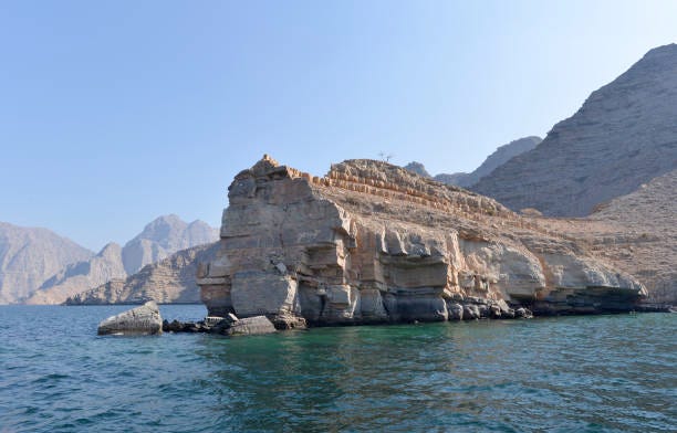
So let’s compare the geographies of those two beaches… The Iranian coastline along the Strait of Hormuz (the northern side of this narrow, strategically vital waterway) and the Normandy beaches assaulted during the D-Day invasion on June 6, 1944, share some superficial similarities as coastal zones targeted in major military operations but differ dramatically in geography, scale, terrain, and implications for amphibious assault.
Both feature a mix of cliffs or high ground overlooking the water and narrower, more accessible coastal strips in places. On the Iranian side near Bandar Abbas and parts of the strait, there are vertical cliffs and mountainous extensions from the Zagros range rising sharply from the sea, providing natural defensive vantage points similar to the high bluffs and cliffs flanking Omaha Beach in Normandy (which rose 100–150 feet and proved deadly for attackers). In both cases, the terrain favors defenders: elevated positions allow observation, artillery fire, and fortified positions (e.g., Iranian islands and coastal batteries vs. German Atlantic Wall bunkers). Both areas involve tidal influences and potential navigational hazards—Normandy had strong tides exposing obstacles and reducing usable beach width at low tide, while the Strait of Hormuz has deep waters but dust, haze, and narrow shipping lanes complicating large-scale movement.
The Normandy landing beaches spanned a continuous 50-mile (80 km) front across five sectors (Utah ~11 miles, Omaha ~10 miles, Gold ~10 miles, Juno ~2 miles, Sword ~5–8 miles), creating a broad, linear assault zone for massive troop landings. In contrast, the Iranian coastline along the Strait of Hormuz is more fragmented and shorter in any potential amphibious focus—dominated by the narrow strait (21–35 miles wide at points, with shipping lanes only ~2 miles each way) and key developed areas like Bandar Abbas, rather than a long, uniform beachfront. Iran’s coast includes a narrow coastal plain with beaches and flats in spots but is mostly rugged and cliff-dominated, lacking the extended sandy expanses ideal for large-scale landings seen in Normandy.
Normandy’s beaches were relatively flat and sandy (with dunes, obstacles like hedgehogs/mines, and seawalls), but backed by bluffs, hedgerows, and flooded marshes inland—creating confined kill zones but allowing vehicle movement once ashore. The Iranian shore is more mountainous and arid, with steep cliffs, limited flat beaches, small estuaries, and inhospitable desert-like conditions (hot, dusty, low freshwater). This would make sustained beachhead establishment far harder, with fewer viable landing sites and rapid chokepoints from cliffs/mountains.
Normandy’s beaches were chosen for their relative vulnerability to surprise assault despite fortifications, enabling ~156,000 troops to land in one day with massive naval/artificial harbor support. An amphibious operation against Iran’s Hormuz coast would face a much more defensible, narrower, and deeper-water environment, with Iran’s control of islands (e.g., Qeshm, Hormuz) and high ground offering layered defenses, missile/drone threats, and rapid reinforcement—making it far less suitable for a D-Day-style mass landing and more akin to a high-risk, limited raid or blockade scenario.
Now let’s look at the aviation support that accompanies each MEU. The Aviation Combat Element (ACE) for both the 31st Marine Expeditionary Unit (MEU) (embarked on the USS Tripoli Amphibious Ready Group) and the 11th MEU (embarked on the USS Boxer Amphibious Ready Group) forms the airpower component of each MEU’s Marine Air-Ground Task Force (MAGTF). In 2026, US Marine Corps MEU ACEs are composite squadrons tailored for expeditionary operations, providing a mix of fixed-wing strike, tiltrotor assault support, rotary-wing attack/utility, and logistics/transport capabilities. These are reinforced (“Rein.”) detachments from various squadrons, optimized for amphibious assault ships like LHA-7 (Tripoli, aviation-focused with no well deck) and LHD-4 (Boxer, with well deck for landing craft).
31st MEU ACE (Tripoli ARG, 2026)
The 31st MEU’s ACE is configured for high-end aviation operations, leveraging the USS Tripoli’s large flight deck for an augmented fixed-wing presence. Key components include:
Marine Fighter Attack Squadron (VMFA) 121 “Green Knights” — F-35B Lightning II stealth fighters (short takeoff/vertical landing variant), providing multi-role strike, air superiority, close air support, and intelligence/surveillance/reconnaissance (ISR).
Marine Medium Tiltrotor Squadron (VMM) 265 (Reinforced) — MV-22B Osprey tiltrotors for rapid troop transport, assault support, and logistics over extended ranges.
Rotary-wing support — Typically includes detachments of AH-1Z Viper attack helicopters, UH-1Y Venom utility helicopters (for armed escort and utility), and MH-60S Seahawk helicopters (from Navy HSC squadrons, for search-and-rescue, utility, and special operations support).
Additional elements — Possible limited CH-53E/K Super Stallion/King Stallion heavy-lift helicopters for outsized cargo/transport, though not always full detachments on Tripoli due to deck space priorities.
11th MEU ACE (Boxer ARG, 2026)
The 11th MEU’s ACE follows a more traditional reinforced composite configuration, with a balanced mix for amphibious assault and sustained operations. It typically includes:
Marine Medium Tiltrotor Squadron (VMM) (e.g., VMM-163 or similar West Coast squadron, Reinforced) — MV-22B Ospreys as the core for troop insertion, extraction, and logistics.
Marine Fighter Attack Squadron (VMFA) detachment — F-35B Lightning II fighters for tactical air support, increasingly standard across West Coast MEUs.
Attack/utility rotary-wing — AH-1Z Viper and UH-1Y Venom detachments for close air support, armed escort, and reconnaissance.
Heavy lift and Navy support — Possible CH-53E/K detachments (transitioning to more K models) and MH-60S Seahawks for heavy transport and utility.
Looks like a pretty formidable force to take a small island, but it is not capable of securing the Iranian coast on the Strait of Hormuz. Here’s another problem… These ships lack the air defense shield of destroyers that accompany a carrier strike group (CSG). If they venture within 500 miles of the Iranian coast they will be vulnerable to Iranian missile and drone attacks.
If Pentagon planners intend to use the two MEUs to seize and secure Kharg Island, which sits in the northern part of the Persian Gulf, the MEUs will have to run the gauntlet of the Strait of Hormuz, which gives the Iranians a much easier set of targets to hit with a drone swarm, missiles, maritime drones, submarines and fast attack boats.
There is one other possibility to consider… Deception. Maybe the Pentagon planners are using the MEUs much like Eisenhower used General Patton’s fictitious Ghost army, which convinced the Germans that the US would land at Pas de Calais rather than at Normandy. Maybe the MEUs are being used to focus Iran’s attention on the Persian Gulf while the US military carries out another mission, such as a ground attack on one of Iran’s underground nuclear facilities that contain enriched uranium.
Here’s the bottomline — The MEUs will not be in position to do anything until the first week of April. If the MEUs are used to secure some portion of Iranian territory in the Strait of Hormuz or take Kharg Island, the resulting US casualties will likely be staggering and the Strait will likely remain shuttered for most maritime traffic.
Here’s my conversation with Pascal Lottaz of Neutrality Studies, recorded late on Thursday:
Here’s the Friday Intelligence Roundtable with the Judge and Ray:
Colonel Wilkerson and I discussed the latest in Iran with Nima:
As part of my Counter Currents channel, I interviewed Professor Yakov Rabkin on the issue of Zionism